Welcome to Mid-Mitten Weather, a student-led meteorology club at Central Michigan University! For more information on who we are and the services we provide, click here.
Current forecasts
7-Day Forecast

Updated: July 15th 2026
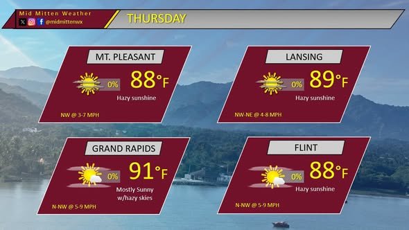
A general cooling pattern looks likely over the next week for the Mid-Michigan area! Tomorrow looks to be another day of above average temperatures with mostly sunny skies, the high looks to get into the low to mid 90s across the state Thursday. Friday is more of the same story, with a high in the lower 90s expected and a slight chance of some evening thunderstorms. Saturday looks to be our most active day of weather over the next week, with showers seeming likely due to a system treking through our area. Thunderstorms cannot be ruled out in the afternoon hours, as it looks like we will have plenty of instability available.
Sunday through Wednesday looks to return to cooler temperatures, with the high temps gradually decreasing from the mid 80s to the mid to high 70s as we begin the work week!
Stay cool and have a great week!
-Forecaster Zach Barker
24-Hour forecast
Updated: July 15th 2026
Good afternoon, Mid-Michigan!
Tonight, temperatures will be in the mid to upper 60’s. The wind will be from the west or northwest at about 3-6 mph with gusts up to 15 mph. Skies will vary from mostly clear to mostly cloudy and hazy skies will be present for all of our area.
Tomorrow morning, any leftover clouds from overnight will dissipate by the afternoon hours bringing mostly sunny to sunny skies. However, the hazy skies are expected to remain throughout the day. Temperatures will climb to the upper 80’s and lower 90's for our area. The wind will generally from the NW at 5-9 mph for most areas; however, it may be variable at times throughout the day.
The hazy skies are expected due to nearby wildfires in Canada. The smoke will have the potential to cause temporary respiratory issues, especially for sensitive groups. Therefore, it is not advised to be outdoors for extended periods of time tomorrow.
-Forecaster Calvin Nader